|
Ras I'r Mor -Race to the Sea – what an exciting title for an event. I knew I wanted to take part the moment I heard about it. And who better to share the experience with than my sister Katie. I made a quick call to her and within the next few hours we had signed up. Of course, for us, it’s time to spend together. We don’t live near each other so this would give us 31miles of walking, to catch up. The route, designed and organised by Cambrian Mountain Events, would take us over part of The Cambrian Mountains by Llangurig and along the River Ystwyth to the coast at Aberystwyth (finishing at the new bandstand). As their literature said - it would be breath-taking, scenic and challenging! I picked my sister up from Newtown station in the afternoon the day before the race- how exciting, coming all the way up from the southeast of England to race to the Welsh coast with me. We have done the Rotary Cross Wales together 5 times but this was something new, something quite different. Couldn’t wait to get the maps out together and go over the route one more time. Couldn’t wait to clear the kitchen table and lay out all our gear and equipment, compare what we had between us and make the final tweaks. Head torch – check, blanket – check, whistle – check and so on. And then of course prepare our all-important egg sandwiches. Katie did these (with eggs from my chickens – the very best) while I cooked a huge chicken and mushroom pie to be devoured for tea. I had made flapjacks the night before and bought some delicious Bara Brith - all essentials for the race ahead. It is not unreasonable or particularly uncivilized to get up at 5am so why lie restless all night? Why not just relax and get a beneficial night sleep? Because I am taking part in Race to the Sea! That’s why. Even so, what was there to worry about? Fitness level, gear, food, the weather – actually nothing major but enough to stop me having the sleep that would have been sensible, but that’s just me. My husband James was kindly taking us to Llangurig – so an early start for him too. Lucky him, at least he would have had slept. No, very unlucky him, not a chance lying next to restless me. Anyway, arrived at Llangurig 6.10am. The village hall was a bit cramped but we squeezed our way through to get a bit of toast and a cup of tea, checked in and received a wristband. My number 930, Katie’s 954. A number is just a number but strange that a number can become so significant, so personal by the end of a day like this one; it is your number and only yours, it means 'you', and you say it as if it's your name at the check points and look for it on the list of timings later, that number will mean so much by the end of the race. We crossed over the road to the start point where everyone had gathered, runner and walkers. Dark and cold, really cold – frosty. We didn’t start right on the dot of 6.30am but not long after. I had walked the very first bit, the Wye Valley, before so it seemed familiar even in the dark. Thank goodness for head torches, negotiating boggy patches in the fields until we came to a lane that would take us up high on to Carnbwlchcloddiau. The tarmac road was so, so slippery – we were trying our best to walk in the narrow gritty bit on the very edge of the lane where it wasn’t icy or at least where we might have more grip. We managed to stay upright but apparently some poor runners slipped over. As it started to get light we could see the top of Pumlumon Fawr covered in snow. Pumlumon Fawr is the highest peak in the Cambrian Mountains at 2468ft/752m. I had texted Katie during the week to say that we might get snow but not really believing it. We climbed higher and higher - it got more and more slippery. The forestry had been cut near to the track and the surface of the stumps were covered in snow, they looked like white discs dotted about either side of the road, quite odd. Always looking back occasionally (one of our mottos) to take in views behind as well as in front, the sun was on the rise and everything was taking on a beautiful orange glow. The view east, back towards the Wye Valley was fabulous and the view ahead was spectacularly remote. It was just fantastic. We felt so privileged, invigorated – buzzing. Just after the first checkpoint it actually started to snow, we could see the cloud coming in and down it came. It just couldn’t get any better. An overwhelming feeling of happiness and appreciation and wanting to savour the moment but time moves on and we had to move on too – after all, it was a race to the sea. It’s a good job that I hadn’t realised that there was a trig point at Carnbwlchcloddiau – I might have had to have made a quick detour to 559m. Near here, before the first check point we reached our highest point of the day, in the Cambrian Mountains - 529m. Over a footbridge, slippery of course, and on to a much rougher track, quite ‘stumblely’ under foot, how the runners do it I don’t know. This took us down to Blaenycwm where we walked through a river side campsite, the river being Afon Ystwyth. I have stayed at this campsite a few years ago, quite an experience – we were bitten to death (we did survive) by midges, and they don’t normally bother me but on this occasion I resorted to rolling myself up inside the picnic blanket – it was the only way. From here the path followed the river over very uneven terrain and still frosty to the checkpoint Ty Mawr (always friendly faces at the check points). And then came the sleety rain. We persevered for a while but it was coming down thick and fast. At least one way to make it stop and see some blue sky again is to put your waterproof leggings on. Guaranteed result every time. So we did this and it stopped raining and the sun came out, perfect! The side of the valley to the right of us was steep slopes covered in disused mines, the colours of the slopes were an amazing mixture of the grey/purple scree and patches of orange bracken. There was the odd tumbledown industrial buildings dotted about too. It was so quiet, still and a beautiful but once having been a noisy, dusty place buzzing with heavy industry – apparently the average life expectancy here was 32 because of lead poisoning. Mining had begun here in this valley as far back as the bronze age - lead, silver and zinc and now just ruins remain. Between Dol-chenog and Pont-rhyd-y-groes we had to consult the Ordnance Survey map a few times but it added to the fun. On reaching Dologau emergency point the landscape was familiar and I immediately recognized it to be Hafod. Hafod was an 18th century magnificent mansion, now sadly only the footing are still there but the grounds, most of it is owned by Natural Resources Wales, and together with the Hafod Trust, manage the preservation. The grounds are well worth a visit if you haven’t been– a spectacular gorge, waterfalls and woodland walks. Pont-rhyd-y-groes check point was going to be round about half way so we here we stripped off our waterproofs, had another egg sandwich and then quickly got going again. The huge foot bridge here spans the river Ystwyth. As we crossed it, eating a lump of yummy Bara Brith, I thought it seemed vaguely familiar – apparently this was our family holiday, en-route to Fishguard, picnic stop in the 1970s. The woodland here, Coed Maenarthur was so pretty and the right time of year to be walking it. The path took us up on to a track which was covered in a carpet of beech leaves but somewhere along here I lost my hat – blast. The view when we came out of the forest looking down the valley was beautiful and must be quite different when the river is in flood. Passed a few more disused mines and then an emergency rendezvous (ER) point. In the next bit of woodland we stopped to have another egg sandwich. I felt I was slowing down a bit - brought on I think by being a bit sad that I’d lost my nice hat. This was our longest stop – 8 mins. It was soon after this that we started to do the ‘Garmin guess’ – every lap (1 mile) my device would buzz and we had to guess our time for the last mile – lots of fun! Our average turned out to be 19.57min. We reached a track after this and were met by a truck which slowed up - we recognized the friendly face – the same face that was at Kerry Pole on the Cross Wales Walk. He kindly gave us some directions for the next bit and asked us if all ok and sent us on our merry way. Seeing a marshal of course is much appreciated but I find it a bit surreal; I think we get so absorbed, so focused on walking and having a conversation almost continually with my sister (usually some nonsense- we would both agree) that seeing and talking to someone else is almost like coming up to the surface, saying ‘hello, yes we are fine thanks’ and then going back down and carrying on. Anyway, fully energised after our refreshment and breather we carried on with a bounce in our stride once again. Soon after following the river from Gwel Ystwyth the route used the disused railway line that used to run from Aberystwyth to Carmarthen. It was closed in 1965 because of flooding and the Beeching report. It is now actually part of the Sustran route 81 (Aberystwyth to Wolverhampton). At Trawsgoed where we met the old train line there was a check point. We picked up some orange segments and topped up our water. Really pleased to see that huge containers of water were being used to refill, instead of handing out masses of plastic bottles. The old railway was pretty and we covered ground very quickly but it did get a bit monotonous - I’d like to try it on a bike it sometime. At last we reached the Glynwern checkpoint with only 8 miles to go. Topped water again and headed up the steep road called Cwm Pantygwyfol. Katie and I thought that perhaps the route took us up high once more before reaching the coast so that we would get a view of the sea. Could we see the sea? No. Ah, well, we would soon. Now for some reason when we started to approach Llanfarian I had a burst of energy and really upped my pace. I don’t think Katie will ever forgive me. She had spent the week prior to the race, walking mountains in the Lake District so was feeling every aching muscle by now. But I sprinted on … and on. She stayed with me though and so did a lady that we met at Llanfarian who was really pleased to have us to keep up with, it really spurred her on. It was lovely to make conversation with her for the last 3 miles – she lived in Aberystwyth but knew a friend of mine from Newtown and also Dafydd Morgan from Tregaron who I know through Mynyddoedd Cambrian Mountains – Wales really isn’t that big. The 3 of us arrived at the bandstand together just before 5.30pm. The sun had about an hour to go before setting over the sea and the starlings had already started to create their murmurations. The bandstand was a great finish point, glad to see it was still standing after the massive storm a couple of weeks before. The live music was lovely and relaxing, just what we needed with a cup of tea. The musician, Tommy Mills happens to be my neighbour so it was nice to have a cheery wave when we arrived. A goody bag full of useful bits and bobs (my favourite being the sweat towel) plus a trophy was a lovely surprise. We were ready to get home after our cuppa so made our way to the railway station to get the 6.30pm back to Newtown only to find that it had been cancelled and that there was a replacement bus service. A slow journey home! Thank you to Cambrian Mountain Events for organizing such a fantastic and successful event and thank you to all the marshals en-route at the check points and the emergency points – always helpful and always smiling. Thank you to Katie for being my ‘Race to the Sea’ partner – we are so lucky that we walk at the same pace, have the same level of fitness (I actually I think Katie is fitter than me) and that we can make conversation almost continuously – a very good catch up! My only regret - not dipping my toes in the sea, but I can do that next time.
0 Comments
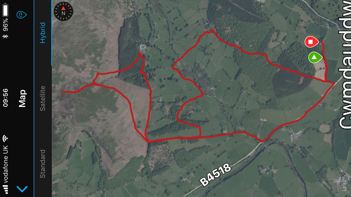
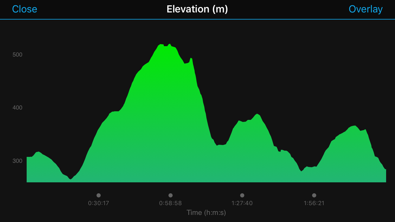
An acquaintance of mine from Mynyddoed Cambrian Mountains had put a bee in my bonnet about trig points. This bee in my bonnet lead me to spending 2 hours one evening last week, scanning several maps covering Mid Wales and making notes on several trig points. Quite an admission - I will happily study a map rather than read a book or watch telly. So I was on a mission to find a trig point with really good views, on a good size hill and on a damn good walk. I also needed a bit of training for Race to the Sea on 27th October so this would be a start. Foel Fadian, which is in the Cambrian Mountains, almost directly north of Pumlumon, is by Glaslyn and caught my eye - 564 metres and it occurred to me that I had walked right past it many times when striding up ‘the big climb’ after the first checkpoint on the Cross Wales Walk, but I hadn’t realised that there was a trig point. This would be an opportunity to go up a little further and get even better views. So, a circular route planned from Aberhoson as follows: bit of the Glyndwr’s way - where I would be looking across the valley to the Cross Wales route, then a diversion to the trig point, back down past Glaslyn, towards Bugeilyn and past Llyn Cwm-byr, taking a bridleway back down the steep slopes to Aberhosan. In short – up, up, up and up............. down, down, down and down. I had a beautiful start from Aberhosan, immediately taking a bridle way down into a pretty wooded area with a stream and a very, very slippery bridge (would have been better to cross the stream I think). Then ‘the climb’ more or less began here, going through a farm - a farm that I straight away recognised – the egg sandwich stop! And there, to greet me, was that lovely sheep dog who had nicked my sandwich (read my last blog to know what I’m talking about). Not sure if the dog remembered me but he didn’t ask if I had brought more sandwiches. Soon onto Glyndwr’s Way from here and a steady, continuous incline now – my only excuse to stop was to take photographs of the increasingly spectacular view or toadstools – proper red ones with white spots. I could clearly see the Cross Wales route across to my left and could even spot where one year, my sister and I, blindly followed another participant up the wrong track. He then helped (heaved and pulled) us up the heathery steep bank, up on to the track where we should have been. It was very funny and he was good company. We gave him lots of encouragement every time we cross paths on the way but I think he called it a day just after Trefeglwys -very well done! Up at the trig point it was magnificent. I felt as if, if I threw a stone it would land on Cadair, it looked so near. I could throw several stones in fact, landing on Cadair, the Arans, Corndon Hill, Plynlimon even into the sea. I stood there quite some time (as long as it takes to eat a banana) taking in the spectacular views. Passed Glaslyn next, not looking that blue today, but at least the clouds were high enough for good views. Glaslyn is the biggest and wildest nature reserve managed by Montgomeryshire wildlife Trust. A track now, I am never very keen on tracks – forestry or cycle path type tracks, I get a bit bored and find it difficult to keep up a good pace but actually I felt bounding with energy after the 425 metre climb (approx.) so making the most of it I marched my way to the next two lakes. The scenery was remote, mostly bilberry bushes and heather, peaty and patches of marsh. I could clearly see Plynlimon beyond Bugeilyn and it looked a good route up there from Glaslyn but I’ll save that for another day. Was I expecting to see anyone? No, not really. Good job, because except for some cyclists at the very beginning I didn’t see a sole, no one, just me and this beautiful countryside. I could talk to myself all I liked and no one would ever know – it’s usually ‘wow, look at that’ referring to the view or a toadstool or furry caterpillar and occasionally, ‘thank god for that’ when at last I see one of those rare species – the lesser spotted bridleway waymark. Just before Bugeilyn is a tumble down dwelling, more like a ruin. A stone property with evidence of brick arch lintels over the windows and doors, a huge timber for the fireplace lintel and in an upstairs bedroom a massive stone as a fire place lintel. My imagination runs wild when I see places like this – in a matter of seconds this place isn’t a ruin, it is a cosy, well-maintained cottage with a neatly stocked log store and sheep with lambs in the adjoining building, I’m living mostly of fish from the lake and have a bilberry pie cooking in the stove. Unfortunately this place is well beyond repair and would need to be bulldozed and started afresh. What a shame – such a beautiful spot – out of this world. Back to my senses and best foot forward to Llyn Cwm-byr where there was an unexpected damn, not huge but never-the-less a lump of concrete in the middle of this remote wilderness. I quite liked the contrast. Using a fence post, which incidentally had a miniature garden in the top of it, as a tripod, I positioned my phone to take a photo, on timer, so that I could run on to the damn. It worked. Great this technology, I thought, but then right at that moment when trying to view the photograph I experienced ‘death of the phone’ which this particular make, mentioning no names - but bears the forbidden fruit on its casing, is renowned for. It has happened to me before in cold weather. I was wearing a hat but I didn’t think cold enough to make my phone give up. How annoying, just when I wanted to take more pictures. I had only said to one of my customers last week that I don’t like to rely on electronic devices when out walking so I always carry a map and compass. My GPS gadget is only to see my route after I have finished and the elevation. I’m certainly not into all the techi heart rate data and so on. Sometimes this device gives up half way round a walk too. Lesson – don’t rely on something that is not relying on you. The view of Plynlimon was really clear from this part of the track. I felt like I was going farther and farther into the wilderness (without a phone and completely deserted of any human life). This on my mind a little, I missed the bridleway going off to the right and before too long reached a boundary and gate. I knew I must have missed it, so backed tracked only by 200 metres or so and found it easily. It wasn’t marked but clearly used quite a bit. This would eventually take me to the steep slopes back down into the valley. So all downhill from here. The track wasn’t the easiest to follow but I did come across one waymark and was happy that I was where I should be and my phone had come back to life. I passed an empty, nearly derelict farm - house on one side of the lane and buildings on the other. A really lovely old building in a very sorry state. I found out afterwards that someone on their bike had called there 20 years ago asking to use their phone. An elderly couple let him in, refused to take the money he offered for the call and gave him tea and cake. I found a footpath, not marked, that would take me across the valley to familiar Cross Wales territory, back to the egg sandwich farm near the start and then be on the home straight. A fantastic walk which was well overdue and has satisfied my trig point mission…. for the moment. 11.7 miles Friday 22nd, the day before RAWW - last bits of preparation; check and check again my ruck sack contents, dubbin boot and shoes, make flapjacks, clothes organised in a pile to put on in only a few hours’ time, eat lots of carbs, medications – mustn’t forget hayfever tab! Check the weather, again! COUNTDOWN!! Pick up my sister Katie from train station, eat an enormous tea – I made a lovely stodgy fish paella – easy to digest and sustaining. Bed by 10pm, set alarm for 2am. Sleep! Alarm goes… 2am…Get up, make a cup of tea for me and my sister, have a quick shower, eat bowl of muesli, get dressed, try not to disturb dog, one last check of kit. Time to go – a short walk from my house down to the buses at Ladywell House car park. What a great feeling. It was a very clear, light night and so still. A few people were milling about after their Friday night social and the odd taxi buzzing around, but we had had our night sleep, we were well and truly into Saturday, being taken on a coach to the coast, dropped off and then we will literally walk the 44miles back across Wales. Is that mad? No, great fun! Not only the walk but a whole day, a proper whole day (the nearest Saturday to the 21st, so about 19hours of light) for me and my sister to chat. Imagine if you were told that you had to sit and chat to the same person for that length of time – it’s a whole lot easier if you are walking and talking at the same time and I assure you, my sister and I don’t find it a challenge, well, not the talking anyway. The atmosphere on the coach was unlike some other years when it has been quiet and you can sense everyone’s apprehension. This time it had a certain excitement in the air – continuous chatter and laughter. I was hungry (so much for the sustaining paella) so ate a yummy flapjack. Katie and I like to sit at the front of the bus so that we can get through the first checkpoint easily and don’t run the risk of getting cold waiting to get through. Glandyfi - At 3.55am we were through the checkpoint and our trek had begun. The air was very cold and it was already getting light, a cloudless sky. It felt lovely and fresh as we set out on the first stint to Cefn Gwyrgrug Farm 7 ¾ miles. One of the best bits is hearing the very first bird sing and then being joined by the whole chorus. What better way to start a walk. There was the odd patch of mist in little dips but other than that it was clearer than we had ever experienced and as we climbed higher and higher the views got more and more breathe taking, especially once on Glyndwr’s Way. ‘Remember to turn round!’ That’s our motto. It is so easy to just keep on walking, missing out on the fantastic views behind you. Not only that, it is so satisfying to appreciate both how high you’ve climbed and also what a magnificent country you are walking in. We were joined early on by quite a young girl walking on her own, her friend couldn’t make it at the last minute. We chatted for a while and then Katie stopped to tighten her boots and we didn’t see the girl again – I wonder how she got on. Cefn Gwyrgrug Farm 6.30am. A confession – we brought our own egg sandwiches! We make quite a big deal about it; bread from Evans bakery, eggs from my own chickens. We give it a lot of thought before the walk and during the first 7 ¾ miles – something to really look forward to with a cup of tea. Once again the organisation at the farm is brilliant and lots of smiles to greet us and a cup of tea at the ready. There was a lovely big old friendly sheep dog with huge puppy like eyes. I ate my first sandwich and then texted my husband to keep him posted on our good progress. I turned to pick up my second sandwich - it had gone! My egg sandwich gone! And there, right by me was that very friendly sheep dog, with those huge round eyes, holding my sandwich in the grip of his jaw. Quite sweet but gutting. Now the climb up to Glaslyn, I don’t think I have ever enjoyed this climb so much. I really felt that every step was so satisfying. My sister timed it – 7.5 minutes to do the climb – it is that significant! The view of Cadair Idris, behind us, was fantastically clear. Once at the top it was warm enough, and we were warm enough, to change our trousers for shorts. Glaslyn really did look blue and the skylarks were going crazy, we felt on top of the world. From the moorland up here you can actually see the wind turbines and mast at Llandinam – the route would take us past these after lunch, about 17miles away. Staylittle. After 7 ½ miles we reached Staylittle, the breakfast stop. It is the only time that my sister and I eat baked beans for breakfast, strange but true. I was starving, the breakfast almost becoming a mirage; sausage, bacon, beans, egg, toast n butter, mug of tea, banana. Picking up the breakfast token at the bottom of the hill is just one step closer to that delicious plate of a good old English breakfast, including beans!!! We did all the usual checks; water, visit the toilet, sun cream, changed our boots for trainers and set off on our merry way, getting our card punched at Staylittle out. The shape of the punches becomes something else that we get a little fixated about – what will it be? A butterfly? A Christmas tree? An apple? So rest assured Newtown Rotary, nothing gets passed us – every bit of your excellent organising is appreciated. From here, there is quite a lot of tarmac, in fact all tarmac to Llandinam, hence the change of foot wear. Down, down, down into the Afon Trannon valley passing a beautiful little cottage right by the river, where we always admire the pretty garden. As we approached Llawr-y-glyn we were amused to see that the ‘good luck’ graffiti on the road, for a couple getting married, was still there– it must have been there years now. Actually, one bit says ‘it’s not too late’. Trefeglwys. Along the straight by Coed Rhyd-y-Carw we had two circling kites above us for ages. It is a beautiful valley and the lane had high hedges that gave us a little bit of shade. We reached Trefeglwys, 6 ¼ miles from Staylittle, where there are always slices of orange. We really welcome them but, and it’s a funny family thing, Katie and I cut our oranges the other way – so if you can imagine, once cut in half, the cut side looks like a pie chart with equal segments, then you cut it again and they are really easy to eat. As I said, a family thing, moving on… Trefeglwys is just about half way and I think we were there at about 12 noon. Going well! More road to Llandinam but with the sun high in the sky and a spring in our step we happily walked on. On the way out of the village we passed an immaculate and regimented veggy garden which we took some time studying; broad beans, peas, carrots, beetroot, all in neat rows – very inspirational. Then a friendly lady painting her fence stopped to talk and offered to fill our bottles. All these little snippets of beautiful surroundings and truly generous and genuine folk make the walk what it is and it really is from beginning to end. For some reason on this stretch we began to talk about what we could eat from the hedgerow and what we would eat if we had to survive; would we chew a grub or just go for ‘the swallow in one whole piece’ – I would go for the latter as would my sister, although we did discuss the merits of chewing; the nutrients reaching our blood stream quicker as the enzymes did their job. Never short of something to talk about! Llandinam. Lunch already. That 5 miles went quickly. My husband James and dog Cooper were there to meet us on the old iron bridge at Llandinam. James had brought our lunches that I had made the night before – pasta and potato salad with feta cheese, seeds, nuts, tomatoes, all fuel for getting up that big hill to the windfarm. We had a can of coke too, kindly provided by the organisers (we could have had one of their burgers too). I really do like a drink of coke, really hits the spot sometimes. So with cards punched (a Christmas tree for ‘Llandinam in’ and a simple hole for ‘Llandinam out’) we said our goodbyes to James and the dog and proceeded to the next check point, only 1 ½ miles but about half way up the long, long haul. The heat certainly made it a challenge and we stopped to offer help to a fellow walker. He had been going about the same pace as us from the start; sometimes he was ahead, sometimes we were, so we had built up some RAWW camaraderie. He rested for a while and we saw him later at the Devil’s Elbow checkpoint and again on completing the walk – well done him. There as some places up on the moorland that I have only ever seen boggy but this time the ground was actually so dry it was cracked. In fact I had walked this stretch on Whit bank holiday, only a few weeks ago, and I had had to climb over the fence to avoid the bog. The track through the wind farm is quite rough under foot, there was no shade and the sun was beating down by this time. We felt really good considering and continued to make our way past the motionless wind turbines on this very still, dry and dusty day. You either like them or not, but there does seem something quite graceful about them, except when they start to turn, making an awful grinding noise, losing their gracefulness and becoming some sort of sci-fi miscreation. Bryn Dadlau. Next stop, checkpoint 10, Bryn Dadlau, windfarm offices. A quick punch of cards by some helpful scouts and off t’ go. We collected some water too. At every check point there is water and the stewards never fail to ask if you need any and never fail to make us laugh before we carry on to the next checkpoint. The next being Devil’s Elbow – always a tricky one, it is only 2 ½ miles but as the crow flies it is probably only about 1 mile – a proper dog leg! It just goes on and on. There is an old but well-kept barn on the way where, every year, there are farmers shearing. They must have been baking in the heat. Not the kind of day to be wrapped up in oily wool and wrestling with awkward sheep. Devil’s Elbow. We love the Devil’s Elbow stop and start thinking about it a long way back (another mirage) – tea, Jaffa cakes, fruit cake and only 7.5 miles to go to the finish. We sat in a shady spot to have a welcomed cuppa and saw a few familiar participants. All the walkers that we had seen quite a lot of on route, now had names; big man, dentist girls, hope people, bright orange top women, sunburn man, the boy. We don’t use much imagination in our naming system - that is quite apparent. The Kerry Ridgeway was in sight and is very familiar territory so to us, the end really was near. The walk was going so quickly, none of it seemed a slog (possibly the hill out of Llandinam but we took it very steadily and I seem to remember we were having a conversation about Roald Dahl for much of the way – a good distraction). Cider House. The next checkpoints are really close together to break up the last stint so we were soon at the Cider House. This is the beginning of the ridgeway where there once would have been a pub/inn for the drovers on their way to the markets in England. More oranges here (let’s not go into how they were cut). As expected the views from the highest point were fantastic – Cadair, Aran Fawddwy, Berwyns – all looking spectacular. We noticed that our shadows were getting really quite long. We hadn’t experienced this on previous years because we were back much earlier. Our plan to be more chilled this year, and enjoy every single moment of the day, worked really well – we felt brilliant and we even had some surplus energy to jog little bits towards the end. In your mind you really can’t imagine running but as soon as you start to run, it relieves your tired muscles. Quite strange, but a really nice feeling. Picnic area. Check point 14 with only 2 ¼ miles to go and the card punch is a flower this time. The fields across to the Kerry Pole were a nice rest on our feet before the tarmac lane to the Anchor. Two little boys handed us an ice pop each, they were so sweet we couldn’t refuse. I had texted James when we were at the picnic area so he would be on his way to meet us at the Anchor. Once on the lane, we really were on the home straight. It is quite a steep downhill to have at the end of a 44 mile walk and if you have sore feet it can be torture but we were bearing up well and crossed over the Welsh/English border amazingly without a problem. After the steep downhill then comes the last incline, just so you don’t get off lightly. As we approached the Anchor pub and lady stopped us to ask if we were sisters, twins even. It wasn’t the first time that we had been asked, on the walk, and it had become quite a joke. Yes sisters but not twins, although we both wore head scarfs, black shorts, the same Bryn Walking tee shirts and, of course, walking at the same pace. The Anchor. Finished! 8pm arrival at the Anchor. James, dog and my son Ted were there to meet us and take a photo. We were so elated and excited. Rotary Across Wales Walk 2018 done! Certificate and tee shirt collected and homeward bound for a well-earned curry (thank you James) and a drink. We were in bed just after 10pm and I can safely say that we had talked from 2am until 10pm, well done to both of us! Oh yes, and we had walked from 4am until 8pm covering 44 miles. Both results pretty good going. Many thanks to Newtown Rotary Club, Cambrian Mountain Events and all the sponsors. Roll on next year. Another walk for training so a fairly flat long distance one that I can do fast. Well that was the intention. I was going to do some of Kerry ridgeway and join up lots of bits that I’d done before but when I looked at the map I couldn’t help but throw a new bit in and make a 15 mile circuit. It was a beautiful and peaceful walk and one that Iam eager to do again in better weather. Starting from the picnic site I walked westward along the ridgeway. Right, I made a mistake….. I checked the weather before I left and, in town, it was actually quite nice, muggy but ok. The forecasted rain had not materialized either so I put on my summer walking shoes and left my coat behind because it is only a pain when it gets too warm. Plus, I only had summer in mind but of course up on the ridgeway it can be very different and it was. The ground was very, very wet – the first bit of track not too bad but extremely sheep pooey. Once on the fields the grass was sodden and the clouds above, not that far above, looked ominously drizzly. My feet got wet with in first 2 miles, I could have rung them out, well my socks at least. Talk about getting cold feet – but I decided that the worst was past and I would stride ahead. Lesson – always wear walking boots and don’t assume it is summer in summer time, when in Wales. So anyway, taking the public access track from near the Two Tumps, a pair of bronze age round barrows (burial sites), that takes you to the source of the River Teme and round the south side of Cilfaesty Hill past High Park on to Panty Hill. The views of ‘The Ring’ from here are fantastic, on the other side of the young Teme valley but I didn't take a photo because it was spoilt by fly-tipping. Finding a lovely path then, a bit of a green lane, down to Lluest which looked like it might have once been a dwelling, all that is left now is some stone rubble and a barn but a beautiful south facing setting. It is places like this that I love to imagine what once was. It’s not necessarily the dereliction that I like but the rush of imagination and being absorbed for a few moments in a different era. There was a stream at the bottom which I did a flying leap over and then continued up the track to a small chapel which looked like was in the middle of a conversion project into a house, possibly needing a boost of some kind. From the sharp bend in the road, where there is a lovely old red phone box, I took a lane almost directly south to meet up with Glyndwr’s way. What I really like about doing new walks is that you can look at the map and plot and plan where to go, estimate the contours and imagine the countryside but it is only when you are actually there walking it that it all takes shape; the fantastic views, the beautiful quaint old lanes, ancient trees and of course, most of the time, the only sound being the birds. This part of Glyndrw’s way was really beautiful with views, quite misty, either side down to little hidden valleys, one of which called Crochan Dingle. The only person I saw on this whole 15 miles was a farmer where the path went through his farm. The dogs were making a racket, so much so that I hesitated about walking through the farmyard. The dogs didn’t appear but the noise was so intimidating that I didn’t trust that the dogs wouldn’t get out of where they were once they saw me. The farmer turned up on his quad and reassured me that they were in fact in a kennel. Once in Felindre and over the River Teme I took a foot path back NW ish to the little lane up to Walk Mill. I was relieved that the path was clearly waymarked but I was just over the border into Shropshire! The paths from Walk Mill up to the Anchor I had done a few times before so I felt like I was on the home straight. When I first walked past the tumble down Walk Mill I dared to go inside and took a picture of the quaint cast iron stove, the second time I walked past there was a big dead sheep in the shed, this time it looked completely different - well on the way to being a proper dwelling. The path turns into a track where you get really good views of Castell Bryn Amlwg, a site of a castle of the 12th and 13th centuries. So, from the Anchor up to the Kerry pole and back along the Ridgway to the picnic site. I heard a cuckoo on the way too, which always makes my day, and a kite came swooping down over me as well. I really enjoyed this walk, bang on 15 miles, bang on 5 hours, extremely undulating (very hilly in that case), varied and outstanding countryside and I only saw (apart from passing traffic which was minimal) one person. Very peaceful! ..... (and all with wet feet) Aran Fawddwy has to be my favourite mountain. When I am there, as with many places in Wales, I really do wonder why there is any need to adventure further afield. Another reason why I love it, is because you can see this mountain from the top of the Vastre (the road from Kerry to Newtown) – on a clear day you can see the contours and shadows and appreciate its vastness as it stands proud of all surrounding hills. It is higher than Cadiar Idris (893m) at 905m and in my opinion more beautiful, has a satisfying varied climb and is a lot less busy. This time, my 6th time up there, I took my mum, niece, and husband. I’m very proud of my mum – she is getting towards 77 and still climbing mountains. We can all aspire to that – lots of fresh air and keeping active. So many book are published and so many programs produced on how to keep fit and healthy. We can read it all, watch it all, but let’s face it – just keep active, get lots of fresh air and eat a balanced, healthy diet. It was a misty start and I had already decided that if the visibility was just too bad (and it can be very changeable) once we reached the first plateau, that I would say turn back and not be too disheartened. The climb up the side of the stream is good fun and at times takes some concentration, the mist and dew had made it very slippery in places. Taking your time is key, not only to avoid wrong footing but to enjoy the whole experience – stopping and turning round to take in the ever impressive views. As we climbed further up towards the mist, the mist itself seemed to get higher too and thinned a little, although when we arrived at the plateau we still couldn’t see the little lake up there. From here taking a right turn, it is an undulating climb, some of it very boggy but boards in places to keep above the water. I think a combination of the mist, dampness and heat rising from the peaty bogs gave the gnats a chance to have a field day - we got bitten repeatedly and this meant that stopping for longer than 2 minutes was really impossible. Blue sky! Patches started to appear and little windows opened up to glorious views. The heat from the sun beamed down and we now had a very good chance of getting to the summit, getting the views that are out of this world and not getting bitten while having our picnic at the top. And that’s exactly how it turned out and we could clearly see Bala Lake. We chose a lovely spot to have our lunch, watching the patchy shadows of the clouds passing over the many hidden valleys and contours of the peat bogs. The way down gives a fantastic position to see the whole horseshoe of Aran Fawddwy and although it can get a little tedious because it is only down and down it is worth taking your time on the descent too, stopping to take in the view of the horseshoe and of Cwm Cywarch, the valley where the start is, and to give your knees a rest if you suffer from achy knees. Highly recommended and it is just as beautiful at any time of year. What a beautiful walk I have done this week. Straight from the door of my house, onto the Severn Way doing an 11mile circular to Gregynog and back to town. I did it in 4 hours exactly so that was good going and a good workout because the terrain between here and Gregynog is very undulating, in fact someone said to me recently that that particular part of mid wales is like the whole of wales squashed into just a tiny area. I had done all of the footpaths before, it was just a matter of joining them up. There were a few cow encounters on the way but with one diversion and just being bold, everything was fine. So, starting on the Severn Way I walked up through Hendidley wood, where the blue bells still look magnificent and up over the Bryn to the Fachwen pool, always a beautiful spot for a snack break. Didn’t see the turtle today but shortly afterwards I did see a hare – that made my day. The Severn Way, after the pool takes you up on to some high ground with fantastic views of the Severn valley, over to Devil’s elbow and the hills above Llandinam. The scenery is stunning all the way, little old roads, gorse, marshland, then blue bells, pretty gullies – it really changes every half a mile. Leaving the Severn way near Bwlch-y-ffridd I took a mixture of footpaths and bridleways to Blackhouse common. On the way up I stumbled upon a lone wild Orchid. What a find! Blackhouse common has, I think, become one of my favourite places so I had a very quick lunch stop here before making my way to Ty Du, a very tidy little farm, and onto the lane. There is a footpath from here that goes into the wood on the south side of Gregynog which I’ve used before and Gregynog would be a great lunch stop if you wanted to make a whole day of this beautiful walk. Today, though, I continued clockwise and found the footpath which has a nice new bridge over Ieithon Brook. Then there were cows! So turning round at the nice new bridge I found another footpath that took me to Coedtrefe Farm. The farmer and his dogs here are always very friendly. From here south, there are a couple of lovely old green lanes and again the terrain and scenery changing and something new to see and take in all the way. At Black Well I turned left to take a foot path that goes steeply up the back of the Bryn, through a willow plantation and out on to Pen-Shwa lane and then a foot path that takes you down across the fields to the hospital road. A walk I’d highly recommend. I wanted to do a bit of territory that I hadn’t walked before so got the maps out and planned a 12mile circular starting at Bwlch–y-sarnau. My drive over from the Llan dod road to Bwlch–y-sarnau was beautiful and I felt really excited about my walk. Parking at the community hall was very convenient, and I noticed that they have a seasonal Glyndwr’s Way café there. So all going well…. Have to say though that I was disappointed with the first third of the walk, which was the Glyndwr’s way bit. I’ll try a different circular next time, maybe south of Bwlch-y-sarnau. I trudged a long a flat and very boggy track through a forest before meeting a lane that took me further north but then on to a very dull forestry track (never keen on them). At last reached the open access land and took the bridleway eastward up high on to Crugyn Llwyd for my lunch stop. I was baking by this time; the track had been very sheltered and as I turned right on to the bridleway there was a very welcomed breeze to cool me down. Fantastic views – usually I know exactly what I’m looking at and name most of the hills but not today, all new. There were a couple of Kites swooping high above and below them a Kestrel hovering a bit and then it would move on. Although the bridleway wasn’t marked the field boundaries were as the OS map (me being a map freak) so I could find my way quite easily. That is one of the best bits for me – finding my way; looking out for landmarks, boundaries, tree plantations and so on… I knew that on the high ground there was a break, of only a matter of metres, in the bridleway but I wasn’t expecting to see an actual sign saying ‘no bridleway’ (bearing in mind that there hadn’t been a waymark in the first place). Maybe an indication that someone has annoyed a farmer along the way - so, so long as I went round the inside of the perimeter of the open access land and re-joined another bridleway it would be fine. Hmmmmm easier said than done and finding the new one took some time but got there in the end. I think if I did it again, but anti-clockwise, I would sort it. Going south now and heading towards Fowler’s Arm Chair and stone circle - I’ve tried to find out more on this but I think little is known except that there was apparently a giant called Fowler. Unfortunately the circle is on the other side of the fence to the path but I nipped over to have a look, there was no one about and I hadn’t seen a sole yet. Just as I was leaving the field a tractor came round the corner and friendly dog. The farmer gave me a friendly wave, thank goodness. Next bit, back through a forest to go back down into the valley. I could hear a mechanical machinery noise going on and low and behold I came face to face with a wall of stacked tree trunks. Thankfully there was a very helpful chappy on a grabber type vehicle who said yes the bridleway was diverted and sent me in the right direction. So back along the side of the valley to Bwlch-y-sarnau feeling very warm in the sunshine and already planning my next walk – south!I wanted to do a bit of territory that I hadn’t walked before so got the maps out and planned a 12mile circular starting at Bwlch–y-sarnau. My drive over from the Llan dod road to Bwlch–y-sarnau was beautiful and I felt really excited about my walk. Parking at the community hall was very convenient, and I noticed that they have a seasonal Glyndwr’s Way café there. So all going well…. Have to say though that I was disappointed with the first third of the walk, which was the Glyndwr’s way bit. I’ll try a different circular next time, maybe south of Bwlch-y-sarnau. I trudged a long a flat and very boggy track through a forest before meeting a lane that took me further north but then on to a very dull forestry track (never keen on them). At last reached the open access land and took the bridle way eastward up high on to Crugyn Llwyd for my lunch stop. I was baking by this time; the track had been very sheltered and as I turned right on to the bridleway there was a very welcomed breeze to cool me down. Fantastic views – usually I know exactly what I’m looking at and name most of the hills but not today, all new. There were a couple of Kites swooping high above and below them a Kestrel hovering and then moving on. Although the bridleway wasn’t waymarked the field boundaries were as the OS map (me being a map freak) so I could find my way quite easily. That is one of the best bits for me – finding my way; looking out for landmarks, boundaries, tree plantations and so on… I knew that on the high ground there was a break, of only a matter of metres, in the bridleway but I wasn’t expecting to see an actual sign saying ‘no bridle way’ (bearing in mind that there hadn’t been a waymark in the first place). Maybe a sign that someone’s annoyed a farmer along the way - so long as I went round the perimeter of the open access land and re-joined another bridleway it would be fine. Hmmmmm easier said than done and finding the new one took some time but got there in the end. I think if I did it again, but anti-clockwise, I would sort it. Going south now and heading towards Fowler’s Arm Chair and stone circle. I’ve tried to find out more on this but I think little is known except that there was apparently a giant called Fowler who sat on a chair. Unfortunately the circle is on the other side of the fence to the path but I nipped over to have a look, there was no one about and I hadn’t seen a sole yet. Just as I was leaving the field a tractor came round the corner and a friendly dog. The farmer gave me a nice wave, thank goodness. Next bit, back through a forest to go back down into the valley. I could hear a mechanical machinery noise going on and low and behold I came face to face with a wall of stacked tree trunks. Thankfully there was a very helpful chappy on a grabber type vehicle who said yes the bridleway was diverted and sent me in the right direction. So back along the side of the valley to Bwlch-y-sarnau feeling very warm in the sunshine and already planning my next walk – south! ,Even though I do a lot of walking I still need to train for the cross wales walk. I find that relatively short, fast and hilly walks really helps along with some more lengthy ones too. I shall be walking with my sister Katie again this year; we are usually the same pace but Katie is doing The London Marathon this year so I think she might have upped her walking speed - I better get training. We didn't take part last year but did all 4 years previous to that. Yesterday I went to Rhayader to do a short, quick and hilly walk. I could have taken some great photos but left my phone in the car so all I have to show you is data from my garmin. I was very pleased with my time because I had to do a fair amount of map reading on the way, that takes up time. It was one big steep climb on the way out towards Elan Valley (and there was a cyclist way up ahead - mad!), up to a bog and then back a slightly different way. Beautiful scenery and views. 6.7miles 2hrs 25mins
A torrential start to today but met everybody in the carpark for the litter pick at 10am, organised by Walking Newtown. It was meant to be last weekend, I think to coincide with Sring Clean Cymru but because of the snow it was postposed the until today. It was a really good turn out, so some went into Dolerw and some of us stayed on the town side of the river and made our way down to the skate park. Sue Newham from Newtown Town Council provided us with all the gear and off we went to pick, pick, pick. What a lot of litter!! We did a 1.5hr stint and collected sacks upon sacks, all sorted out for glass/plastic and cans/litter. A few less plastic bottles to get into the river and find their way down stream and eventually into the sea! Generally I tend to think that bridleways are going to be better marked than footpaths. Well not today – completely wrong, never the less a walk that took me right into the wilderness and with a bitter east wind it really was a Siberian experience. I was on a mission today to go up Graig y Lyn-mawr. It has a trig point of 485m and I have looked out towards it many times from Bryn Du. I parked up in Adfa and walked towards Carmel caravan park, past the fishing pool and up as far as the first cattle grid. On the way I stopped to talk to a friendly, old farmer (and his dog) who was giving some hay to his sheep, He had lived in the small farm across the fields, Ty Hir, all his life (born and bred) and has gone to school in Adfa. He said so much had changed but he seemed happy. We were both happy that it was dry at last even if it was freezing. Up at the cattle grid I bumped into another friendly farmer and I decided to check with him where the bridleway went from here because it really wasn’t clear. The conversation went like this. Is there a bridle way from here? Yes Ah right, does it go up to the right, alongside this fence? Yes Ah right, great, thank you. Don’t open any of the gates, mind. Climb over them. Oh I will, I always do. And mind you climb over the hinge end. Oh I will, I always do. Cus it’s me that ‘as to mend them. I’m always very careful. I thanked him very much for his help and went on my merry way. He was a bit economic with his words but helpful all the same. I think we both found the conversation quite funny. It was very boggy in places, as usual, but not too bad. The scenery really was getting magnificent and I wanted to take so many pictures. I had really good views across to Mynydd Cerrigllwdion. Then things got tricky… there were no waymarks, the field boundaries didn’t tie up with the map and I got cold from checking the map sooo many times. All good fun though. I needed to find the bridleway that would take me south, over Graig y Lyn-mawr which eventually I did but there were so many tracks up there, a shame really. It looked like it was a place to come up and have a spin in a four by four. The hill must have so much history- there are so many ancient sites marked on the map which are all bronze age burial/ritual sites. A pity the surrounding land is getting churned up. The geology of the craggy top would be very interesting too, I’ll try to find out. I was very relieved to reach the trig point, the return journey was going to be a lot, lot easier. Views down to the lakes were spectacular. At the lane I turned left and walked up to where a track takes you to the other lake but this time I was taking a foot path to the left. I wasn’t expecting this to be even marked but here was a shiny new gate and then another, and then another, and then another all the way back across the fields. The path went through a group of cairns and right up close to the foot of the wind turbines. First of all the path was just below the peak of Mynydd Cerrigllwydion and I felt quite sheltered but it soon opened out and I was head-on into the bitter east wind. Easy all the way back. 12.2 miles – freezing, fun and exhilarating. |
Archives
April 2024
Categories |
 RSS Feed
